Why do Tropical Cyclones Occur?
Tropical Cyclones are experienced in northwest Australia between the 1st of November to the 30th of April when the season is running. Usually about 10 cyclones will develop over Australian waters each year and only about 6 of these will hit the coasts.
Location:
Tropical Cyclones are mostly experienced in Northwest Australia between the following places:
They occur mainly on the coastline between Broome and Exmouth and they have had the highest amount of Tropical Cyclone crossings recorded in Australia.
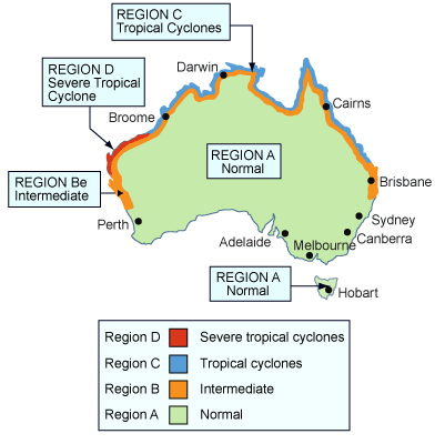
The map below shows where the Tropical Cyclones impact in Australia and their severity level.
Location:
Tropical Cyclones are mostly experienced in Northwest Australia between the following places:
- Between Exmouth and Broome (Western Australia)
- Between Port Douglas and Maryborough (Northeast Queensland)
- Occasionally down the East Coast
They occur mainly on the coastline between Broome and Exmouth and they have had the highest amount of Tropical Cyclone crossings recorded in Australia.
The map below shows where the Tropical Cyclones impact in Australia and their severity level.
Weather Patterns:
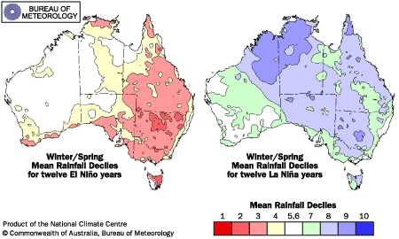
Tropical Cyclones in Australia are influenced by the El Nino - Southern Oscillation (changes in the sea surface temperature to much warmer) and La Nina - Southern Oscillation Index (making the sea surface temperature much cooler). There were also many more Tropical Cyclone crossings in the El Nino years than in the La Nina years.
Tropical Cyclones in Australia form over warm ocean waters off of the north-west and north-east oceans above northern Australia. They will not form unless the temperature of the ocean surface is above 26.5 Degrees Celcius.
As the climate of the world changes over the years the Tropical Cyclones will also change, causing them to become more frequent.